- Home
- About CATS
- The Transect
- Transect Codes Council
- Resources & Links
- Contact CATS
- CATS Programs
- Research
- Publications
- Education
- AWARDS
- CATS TOOLS
- Codes
- Modules
- Images
All images are available for free download for use in PowerPoint (low resolution) or print (high resolution), with credit as noted.
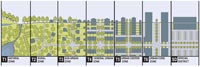 |
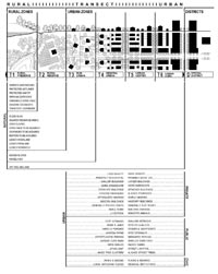
Rural-Urban Transect This is the current (post-2008) Transect diagram with six normative Transect Zones (T-zones) used for the zoning of urban areas as well as natural lands. It is intended to be as general as possible in order to serve model codes like the SmartCode. The elements are drawn in section above and in plan below. Duany Plater-Zyberk & Company |
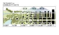 |
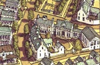
The Transect and Community Units With a return to the overlapping T-zones found in some early DPZ diagrams, this 2011 version clarifies the practice of the SmartCode, whereby the T-zones are allocated within Community Units (ped sheds, approximately), not the other way around. Thus, CLD (hamlet) contains T2/3/4 and TND (village/neighborhood) contains T3/4/5. RCD (downtown) is the most urban neighborhood, containing the three most urban Transect Zones. Sandy Sorlien / Smartcode Local |
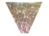 |
Wedge Transect The wedge shape of this naturalistic illustration signifies that the more urban Transect Zones, with their greater density, use less land per capita than the more rural zones. Duany Plater-Zyberk & Company |
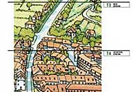 |
European Transect This illustration is from the early plan for Echternach in Luxembourg. It is a vignette extracted from a full drawing that is eight times this width. The T-zone assignments were subsequently applied by DPZ. Leon Krier |
 |
American Transect This transect was drawn to create an American version of the European transect drawing by Leon Krier. Duany Plater-Zyberk & Company / James Wassell |
 |
Physical Characteristics of the Transect This diagram from a very early SmartCode shows that virtually every element that comprises the natural and the cultural may be put into relative order by the rural-urban Transect. This is a summary list of the elements that should be calibrated for code writing. The intention of the SmartCode family of municipal regulations is the avoidance of monocultures. (The Rural Preserve and Rural Reserve zones were changed to the Natural and Rural zones several years ago.) Duany Plater-Zyberk & Company |
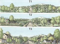 |
Successional Transect Zones The Transect is a progression from rural to urban, but it also has a temporal manifestation. This series can be understood as a city maturing as certain zones become more urban over time. This is analogous to the “successional” concept in nature in where grassland prairie gradually evolves to woodland, and then to a climax forest. In urbanism, the climax would be the equivalent of an area designated for historic preservation. Duany Plater-Zyberk & Company |
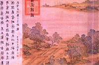 |
Ancient Scroll These four images are periodic extractions from a continuous 40-foot scroll, which illustrates a Chinese transect. While different in detail from a North American transect, its existence supports that the Transect is a cross-cultural phenomenon of the human habitat. Museum of Taipei / Duany Plater-Zyberk & Company |
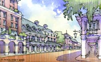 |
Frontage Transect This set of illustrations illustrates a full declension of the building frontages that correspond to the Transect Zones of a SmartCode calibrated for Sarasota, Florida. Duany Plater-Zyberk & Company / Michael Morrissey |
)
)
)
)
)
)
)
)
)